
The GeoSolutions MapManager is a plug in extension for ESRI products. Simply install the extension, register, and create the various map groups....simple! Available for
ArcView 3
ArcGIS 8+
ArcIMS
Requires POINTER or COMPAS dataset from OSNI for address gazetteer.
Complements the GeoSolutions NTF Translator
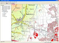
When viewing OSNI or OSI mapping in GIS, the user requires mapping to load seamlessly with no intervention. Manually loading maps is not only time consuming, but can lead to frustration when incorrect maps are loaded. This is especially true when dealing with the large scale vector mapping where there are thousands of tiles, and potentially 10's or hundreds of individual layers.
OSNI mapping is very feature rich, and the GeoSolutions MapManager plugin for ArcGIS allows users to fully exploit this data in a cost effective and user controlled way.
The MapManager also includes an easy to use street gazetter which makes use of both OSNI COMPAS, or the newer POINTER data sets.
The Ordnance Survey data shown in these website pages is Crown Copyright material and Ordnance Survey is the copyright owner of the Ordnance Survey Data.
For the 2001 Northern Ireland Census, NISRA Geography unit was tasked with producing over 5000 maps for the census enumerators. Each map had to show the large scale vector coverage for each map seamlessly. To produce these by manually loading the maps would have been extremely time consuming. Using the MapManager to automatically load mapping, and the GeoSolutions Plot Tools to automate the plotting of maps without user intervention, NISRA were able to produce the output maps quickly and efficiently.
Automatic load and unload of maps as user zooms and pans
Automatic change from one scale of mapping to another as user zooms in or out
Automatic loading of user preferred layers (e.g. roads, buildings, field boundaries etc)
Automatic assignment of preferred legends or colour schemes
Support for all large and small scale OSNI mapping (raster and vector)
Support for new Ortho-photography
Zoom to theme - zoom to townlands, wards (based on appropriate vector data-set)
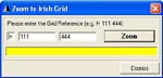
Zoom to Grid Reference
Zoom to street (if POINTER or COMPAS data sets owned by user)
Fast and efficient use of OSNI maps
Eliminates confusion when working with multiple maps
Greatly reduces time and effort in preparing composite maps of towns, villages, settlements etc
'Point and Click' automatic map loading - no need to know map names
Use and interrogate via familiar OSNI map sheet names if known or preferred
Release the full power of POINTER and OSNI large scale together