Building managers, especially on campus facilities, require up to date information
on the space available to them, how it is used, and more commonly, how is this resource
charged to various users. They require the ability to see how the campus is used,
and have reporting capabilities on tap for project meetings. BuildIT space
management is a unique combination of GIS, CAD and reporting to give managers
the information the require, as they need it.
to various users. They require the ability to see how the campus is used,
and have reporting capabilities on tap for project meetings. BuildIT space
management is a unique combination of GIS, CAD and reporting to give managers
the information the require, as they need it.
First developed for University College Dublin (Ireland), BuildIT has proved
so useful to  managers
that it has now been redeveloped in ArcGIS, TatukGIS and Oracle to make use
of newer technologies to give even greater access to information. BuildIT combines the GIS power
of ArcGIS with Oracle database to give reporting power to the various building
managers on campus. All this information is also available over the intranet
to give further flexibility to the system.
managers
that it has now been redeveloped in ArcGIS, TatukGIS and Oracle to make use
of newer technologies to give even greater access to information. BuildIT combines the GIS power
of ArcGIS with Oracle database to give reporting power to the various building
managers on campus. All this information is also available over the intranet
to give further flexibility to the system.
Tadgh Corcoran, University College Dublin, Building Service Manager said
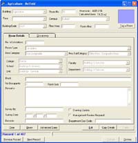
Access building plans and SPACE plans from building list, or from map.
Support for AutoCAD building plans within GIS.
Rooms colour coded by college, faculty and other cost codes.
Customised edit tools to create new rooms using tracing and other intuitive tool sets.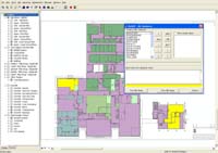
Flexible query tools to interrogate all aspects of the campus database.
Room details, including occupier, edited by user but seen immediately by all.
Link to other user defined tables
Extensive reporting facilities in both MS Word, Excel and HTML
Create reports by cost code to ensure better cost recovery
Plotting facilities to create room plots for meetings/ contractors
Link to Web Based GIS
Link to hand held PDA's and bar code readers for enhanced data management
All building managers have access to the same up-to-date data at all times
Easy to visualise and report on SPACE useage within the campus
Use of cost centres and cost codes included for enhanced and fairer cost recovery from various departments/colleges
Cost recovery for utilities of shared space (if required)
Easier to track what SPACE is used by which department and where
Information accessed from several means - desktop, Intranet and handheld PDA
Use of bar code readers enhances management of assets such as PC's and furniture
Based on ESRI ESRI ArcGIS 8.x +
Microsoft Windows operating system - XP or 2000
Pentium 4 processor or above
256MB RAM
Database requirements - Oracle, MS SQL Server or MS Access
Desktop or full campus enterprise
Web browser - TATUK GIS or ArcIMS
UCD is a large campus university on the southern side of the city of Dublin, Ireland. Their campus
is the largest in Ireland and encompasses a diverse range of buildings, faculties
and departments. In 1995, they saw a requirement for a system which would
give them greater reporting capabilities on room useage by various departments and faculties.
GeoSolutions installed BuildIT for UCD, then running on ArcView 3 and MS Access. It has proved a great asset to building managers, enabling them to create reports and plots, and publish these on the local intrant.
With increased changes on the campus, and a move
towards cost recovery, UCD saw a requirement to update BuildIT to make use
of newer technologies, and give greater access and flexibility to building managers. Using ArcGIS 9 and Oracle
database, staff have been able to meet their requirements for cost recovery.
Oracle gives greater flexibility for data storage, and can store all spatial
data within a robust secure RDBMS.
greater access and flexibility to building managers. Using ArcGIS 9 and Oracle
database, staff have been able to meet their requirements for cost recovery.
Oracle gives greater flexibility for data storage, and can store all spatial
data within a robust secure RDBMS.
This option gives further flexibility for rebuild of historical changes to floor plans, and audit trail tracking to see what floor plans were changed, when and by which user.
UCD are barcoding all assets (furniture, PC's etc) and bar code readers can be used to track what asset is in which space. As cost recovery requirements increase, BuildIT has the flexibility to accomodate this.
Whilst CAD diagrams can show the original building plans and area for an individual room, they do not typically automatically link to a centralised database to give an overall report on how much space is used by departments and where. Within BuildIT, each room and shared space is captured as a polygon from CAD drawings (either paper or digital). This polygon is then attributed by various criteria including department, faculty or other cost codes, occupiers of a room and how much room with shared space. Assets for each room can then be attached such as furniture and PC's, and this can then be updated using bar code readers. Reporting is then very straight forward from the central database.
Because similar jobs will be done on all rooms (tracing, dividing and merging), we have been able to customise ArcGIS so that the various edit tools are easy and straightforward to use ensuring that training is minimised and users are up-and-running quickly.