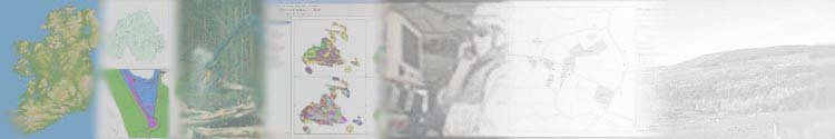
In an ever expanding information hungry world, Internet GIS is the ideal way to publish spatial information to the general public, or across your organisation, in an easy and intuitive way. Browser based technologies mean that information can be distributed to anyone with access to an internet browser.
This technology is also a means to help achieve targets for delivering e-government objectives.
ArcIMS from ESRI fits within the ArcGIS family of products.
With its built in author
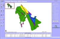
software, users can quickly and easily build working sites to distribute information
to users. More advanced site construction can be achieved through coding in
HTML, Java or .ASP.
GeoSolutions are experienced in complete set up and maintenance of ArcIMS, from installation of software, design and creation of effective websites, to on-going maintenance.
As an alternative to ArcIMS, Tatuk GIS have developed a user friendly and competitevely priced Internet GIS system.
Contact us to find out how internet GIS can deliver spatial data to your business or the public.
With the use of GPS on the increase, there is an increasing demand to not only take mapped and associated data into the field, but also have the power to update this data there and then, rather than wait till you are back in the office.
For hand held devices such as PDA's (personal data organisers),
we can offer solutions in ESRI ArcPad software. This allows users to access
data from an easy to
use and intuitive workspace. This can be linked to other devices such as GPS
units, rangefinders and digital cameras, to aid in information gathering.
Communications can be included using GPRS technology which can allow data
to be transmitted back and forth in real time (this will depend on local conditions
for available signal).
If units do not need to be carried, or more power is required, applications can be developed for ruggedised laptops. More power is required, however the application will generally require to be very customised. This can be achieved with either ArcGIS, or a completely custom application using ESRI MapObjects. TBMS for the defence market is developed in MapObjects and is taken into the field on ruggedised laptops. Communications is achieved through data transmission over military radios, and positioning through connections to an embedded or standalone GPS receiver.
We have a wealth of experience in mobile applications.
We can also procure and advise on various devices from PDA's to rugged laptops.
Contact us to find out more.
GIS within larger organisations brings further challenges, that not only includes scalability of a solution, but data management, data security, and differing demands on the data and system.
From a data security aspect, the solution will more than likely incorporate an industry standard Relational Database Management System (RSBMS). There may be scope to start afresh, however these systems will often fit in with systems already in use.
Options include Oracle, Oracle Spatial or MS SQLServer. GeoSolutions have devloped techniques to store spatial data within Oracle and SQL Server, or you may opt for ESRI ArcSDE - the ESRI solution to storing and managing spatial data in a RSBMS.
Enterprise solutions may make use of floating licences for ArcGIS software and extensions, whereby the business will purchase a number of licences which can then be checked in and out by users as required.
For many users, an Intranet GIS solution will serve their needs, with a central core of users who manage the data.
Essential to this is high quality focussed training for all users to ensure they make full benefit of the system.
From initial project initiation, to system design, build, training and on-going support and maintenance, GeoSolutions are well placed to advise you.
With any GIS solution from single desktop, to full enterprise, benefits can be gained in productivity through streamlining workflows. Although the tools may be available within ArcGIS, it may take several time consuming steps to achieve a result. In other instances, certain functionality may need to be locked from the user, or automatic coding systems applied. These capabilities and many additional processes can be achieved through bespoke application development.
GeoSolutions will look at the various workflows and design a suitable application to achieve your result. This can be completely automated, or incorporate user intervention. User suitable toolsets, such as ArcObjects, or MapObjects, we can design an application to meet you needs:
Some examples of our projects include:
FSGIS
Forestry management software (ArcObjects)TBMS
Battlefield Management and tracking system (MapObjects)PlotTools
Automated plotting application - used by Roads Service to design templates and print from a database, and by NISRA to automat the plotting of over 6000 census maps (Avenue and ArcObjects)RSBMS
Bridge Management System for Roads Service NI (Avenue)Groundwater Management System
Used by Environment and Heritage Service NI to input and process land areas for agricultural chemical dispersal (Avenue and MS Access)Prawl, HMO and Carto applications/toolsets
Developed for Northern Ireland Housing Executive, these tools enabled the agency to gain more power from their data.
Contact us for more information, or to see examples of these projects in operation.
ESRI ArcGIS is one of the leading desktop GIS software in the world. Built on industry standards, it provides exceptional, yet easy-to-use capabilities out of the box.
The software provides core mapping and GIS functionality, geographic data visualisation, query, analysis, as well as the capability to create and edit geographic data.
The capabilities of ArcGIS can be extended with a range of extensions to build on the core functionality:
Spatial Analyst - to interrogate and analyse grid data sets
3D Analyst - build and visualise 3 dimensional models
GeoStatistical Analyst - statistics in a spatial environment
......and many more.
Choose the add-ons to suit your requirments.
Contact us for a competitive quote for ArcGIS and any extensions you require.