
Based on industry standard GIS technology
Built in Map Objects - no requirements for additional GIS software
Windows XP, 2000, etc.
Supports ITT Sincgars or Bowman radio
Can be used with other leading radio or communications systems
Utilises standard commercial or military GPS technology
Military standard symbology and messaging
Extensive list of supported map formats

Todays
Military Commanders are looking for a system that provides the common picture
of the battlefield. Employing the latest advances in technology, TBMS provides
this capability effectively, by giving comprehensive real-time 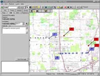 Situation Awareness
(SA) and Command Messaging (CM) facilities to the people who need it.
Situation Awareness
(SA) and Command Messaging (CM) facilities to the people who need it.
TBMS enables live electronic monitoring and control for field and operational command at Brigade and lower echelons. This allows Battalion, Company, Platoon, and other commanders to interact and maintain a complete picture of field operational scenarios.
The SINCGARS - Tactical Battlefield Management System (TBMS) software application integrates the capabilities of the SINCGARS Advanced Tactical Communications System (ATCS) with leading edge computing technologies in an easy-to-use and effective solution. The developers of the SINCGARS ATCS radio, ITT Industries A/CD, are working closely with GeoSolutions to ensure that TBMS is optimised to take full advantage of these advanced capabilities.
TBMS provides complete functionality for monitoring field and related activities. Positions are accurately located and displayed on a digital map background directly from the SINCGARS embedded GPS receiver. Information is distributed via the radio, using integrated IP networking capabilities, allowing for a complete electronic picture to be seen at all command levels as required.
S-TBMS enables immediate reporting and instant command notification using the easy-to-use efficient Command Messaging functions. Situation, Spot, and other reports, as well as Command Text Messages and other data can be distributed directly over the radio network, and displayed on the map or alerted to the recipient in an appropriate way.

TBMS has a built in data projection facility to transorm data from one format to another. For other issues, we recommend using ArcGIS to transform, project and register images before using in TBMS. One seat of ArcGIS is usually enough to handle all these requirements.
The Bowman radio is based on the ITT SINCGARS radio, and should therfore operate fully. For other radios or comms equipment - we will be happy to test and explore modifications for you.
The Irish Defence Forces having been using TBMS for over 7 years. Originally known as SARTRACK, the system was used initially within Ireland to track military vehicles in their day-to day operations.
In 2004, TBMS was used by the Irish Defence Forces for peace keeping duties in Europe, and also Africa.
S-TBMS provides full functionality to allow display and distributing of near real-time information around the Battlefield, however large or small the area of interest is. Each radio, command node, or configurable group of nodes can be selectively and automatically tracked, and displayed clearly with appropriate military symbology (MIL-STD-2525). Details of the unit are also transmitted and displayed to allow quick and clear identification. Alerts can be triggered to warn of any significant action or inaction, such as entering a restricted zone, stopping unexpectedly, etc. Additionally, a full history of each tracked route can be displayed, and any activity can readily be recorded for later playback.
Key features of S-TBMS are:
Military and other digital map formats supported
Tracking of individuals or groups
Situation overlays (e.g. zones, minefields)
Record and Playback of tracked routes
Alerts triggered automatically
Distribution of Command Messages and Reports
Full military and other symbology
Easy to use with minimal training requirements