
FSGIS is the innovative management tool to assist in future forest management. Running on ESRI ArcGIS, the application has been developed to meet a range of specific requirements:
Do you need to.........
.....have the answers to forestry management at your finger tips?
.....produce professional maps and reports for clients or customers?
.....run production forecasts on your forest estate?
.....edit your forest coupes and compartments in an easy and user friendly way?
.....see the estate in relation to utility or natural heritage data?
Whether you are managing private commercial woodlands, or managing state/ government forests, then FSGIS can meet your needs!
The Forest Service is an Executive Agency of the Department of Agriculture and Rural Development. The Department is responsible for promoting the interests of forestry in Northern Ireland, the development of afforestation, the production and supply of timber and the maintenance of adequate reserves of growing trees. The Agency is required to deliver current policy through a programme of sustainable management and continuing development of afforestation to produce a range of benefits, which are in balance with the economic, environmental and social interests of rural areas.
 As
the largest landowner in Northern Ireland, the Department is accountable for
the management of approximately 75 000 hectares of public forest estate, and
has responsibilities in the grant aiding and administration of approximately
14 500 hectares of private woodlands across Northern Ireland.
As
the largest landowner in Northern Ireland, the Department is accountable for
the management of approximately 75 000 hectares of public forest estate, and
has responsibilities in the grant aiding and administration of approximately
14 500 hectares of private woodlands across Northern Ireland.
Within Forest Service, it was recognised that GIS technology had significant potential to inform and facilitate the delivery of Northern Ireland forestry policy objectives. The Forest Service initiated a project to procure a GIS, customised to meet the requirements of the Agency.
Following a full EU procurement process, and detailed evaluation of proposals, by Forest Service, over a period of months, GeoSolutions was selected as the preferred supplier for the project. The solution was based around ESRI, ArcGIS and ArcIMS, and Oracle technologies.
Historically, estate information was based upon a series of paper maps that were managed and maintained by a centralised Planning and Cartography Branch based in Forest Service Headquarters in Belfast. This function was supported by a combination of a paper-based filing system and a separate Sub-Compartment Database, which was maintained within the Department.
Management of this information has now been transferred to FSGIS, with the Planning and Cartography team trained in its effective use.
In developing the project, a requirement was to effectively
create a ‘two-tiered’ system in which a ‘High End’ PC-based
capability was provided for a number of identified users who would be expected
to operate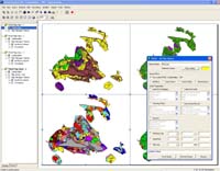 the system as ‘expert’ users with pre-defined permissions e.g. edit,
delete, roll-back etc. Supporting this would be a ‘Low End’ Intranet-based
system, which would be available to all Forest Service staff, allowing individuals
to view, query, redline and print.
the system as ‘expert’ users with pre-defined permissions e.g. edit,
delete, roll-back etc. Supporting this would be a ‘Low End’ Intranet-based
system, which would be available to all Forest Service staff, allowing individuals
to view, query, redline and print.
Castlewellan, Enniskillen and Garvagh district offices have access to the main FSGIS system. A forester specially trained in ‘High End’ FSGIS in each district office is responsible for delivery of planning functions and information management using GIS. Additionally, district harvesting teams have been trained to use ‘High End’ FSGIS for operational analysis and planning tasks.
These four offices are kept in constant server synchronisation. The ’High End’ users have full access to all data for editing, reporting, querying as well as running production forecasts to value future timber extraction.
With the relevant permissions, users located across Northern Ireland can input data into the system, which automatically updates information for all users in the Forest Service.
 The
combination of secure ‘Low End’ use and redlining functionality
is clearly benefiting the Forest Service as maps/tables can be instantly sent
and received from any location. Any such material can then be scrutinised
and approved for integration into the protected ‘High End’ system.
The
combination of secure ‘Low End’ use and redlining functionality
is clearly benefiting the Forest Service as maps/tables can be instantly sent
and received from any location. Any such material can then be scrutinised
and approved for integration into the protected ‘High End’ system.
This facility has already shown huge benefits by allowing foresters to return
the 2005 planting maps for updating much faster than in previous years.
The ‘High End’ system has been heavily customised in ArcGIS with bespoke editing tools, querying and labelling, as well as functionality to analyse potential operational scenarios, including advancement or deferment of crop harvesting schedules, with data checked out of the system whilst these scenarios are run. The system includes audit trails, and a rollback facility enabling users to see any forest at any point in the life of the system. Harvesting foresters can run production forecast models using Woodplan (a specialist forestry software package), integrated into FSGIS, to assess timber values at any point in time. These results can be mapped, and scenarios compared.
Within a very short space of time, FSGIS has provided benefits
to the way foresters manage their work and has led to many Forest Service ‘in-house’ projects. Forest fires
have major impacts on the Forest Service estate, both financially and environmentally.
The system has enabled historical fire damage maps to be captured and compared
temporally to build up patterns of fire occurrence and relate these to probable
causes. Woodplan can then be used to calculate the financial loss to the Forest
Service had these stands been allowed to grow to full economic maturity. From
this study, a Forest Fire Emergency Plan has been created which will be easily
accessible to all users, enabling the Forest Service to target prevention
measures more effectively. These plans can be shared with the Fire Service
when tackling any fire outbreaks and in the future may be made available to
each mobile fire unit electronically and thereby allowing fires, and resources,
to be managed more effectively.
and has led to many Forest Service ‘in-house’ projects. Forest fires
have major impacts on the Forest Service estate, both financially and environmentally.
The system has enabled historical fire damage maps to be captured and compared
temporally to build up patterns of fire occurrence and relate these to probable
causes. Woodplan can then be used to calculate the financial loss to the Forest
Service had these stands been allowed to grow to full economic maturity. From
this study, a Forest Fire Emergency Plan has been created which will be easily
accessible to all users, enabling the Forest Service to target prevention
measures more effectively. These plans can be shared with the Fire Service
when tackling any fire outbreaks and in the future may be made available to
each mobile fire unit electronically and thereby allowing fires, and resources,
to be managed more effectively.
Using digital data from other organisations including Planning Service and Northern Ireland Electric, as well as forest composition and location parameters, Forest Service was able to identify possible areas for locating a proposed biogas plant creating green energy.
Utilising the 2001 census data, socio-economic factors can be more easily mapped and modelled which will ensure that recreational forests are made more accessible to the general public and limited resources are targeted most effectively. This will be further refined when the deprivation indices are released in June 2005.
These projects are just a small sample of those so far conducted and proposed within the service.
Forest Service already has plans to introduce mobile GIS
to complement the mobile GPS units it  operates,
and will continue to develop its modelling capabilities with Spatial and 3D
analysis using the Ortho-photography and terrain model due to become available
this year. Links to the web based Timber Permit Management System will allow
timber to be tracked more easily from felled area, to sawmill, to end user.
operates,
and will continue to develop its modelling capabilities with Spatial and 3D
analysis using the Ortho-photography and terrain model due to become available
this year. Links to the web based Timber Permit Management System will allow
timber to be tracked more easily from felled area, to sawmill, to end user.
The Forest Service has developed an effective working relationship with GeoSolutions and sees this as very much a partnership project with the potential to go from strength to strength.
Malcolm Beatty, Chief Executive of Forest Service says,
FSGIS has been adapted so that GIS is available to Foresters using language and methods, which are familiar to them. The tools and features have been designed to ensure the forester can become productive in a very short space of time. FSGIS is built on ESRI technologies and is designed as an extension to ArcGIS.
Key features include:
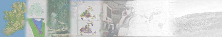
FSGIS has bespoke reporting tools to query all aspects of the estate. Summary
reporting gives a breakdown by % of species, land use or other attribute.
Summaries can be at estate level, down to coupe/compartment level. The query
builders allow the user to build up complex queries based on attributes, and
report either spatially, or to Word/Excel. FSGIS also has a comprehensive
plot facility where pre-defined plots can be saved as templates. Reports can
include both maps and text output from the system. A comprehensive graph builder
can give important information in a easily readable format.
Summary
reporting gives a breakdown by % of species, land use or other attribute.
Summaries can be at estate level, down to coupe/compartment level. The query
builders allow the user to build up complex queries based on attributes, and
report either spatially, or to Word/Excel. FSGIS also has a comprehensive
plot facility where pre-defined plots can be saved as templates. Reports can
include both maps and text output from the system. A comprehensive graph builder
can give important information in a easily readable format.
FSGIS has a range of bespoke editing tools to make update of forest maps both
easy and intuitive. New compartments can be traced against existing linework;
overlapping compartments are automatically trimmed to ensure overlaps do not
 occur.
A rules set ensures that incorrect attributes are flagged as incompatible.
Whilst the coupe is edited, the data is locked to ensure other users cannot
edit the same data. Other features include creation of buffers, split by trace,
island polygons, felling coupes and much more. All new compartments are coded
appropriately to ensure uniqueness for all compartments in the system - essential
for auditing.
occur.
A rules set ensures that incorrect attributes are flagged as incompatible.
Whilst the coupe is edited, the data is locked to ensure other users cannot
edit the same data. Other features include creation of buffers, split by trace,
island polygons, felling coupes and much more. All new compartments are coded
appropriately to ensure uniqueness for all compartments in the system - essential
for auditing.
Key to the operation of FSGIS, especially at enterprise level is its Administration facilities. Administrators can create and manage all users, ensuring the system runs smoothly. Full auditing is available, so the administrator can track changes made and when for all the estate, and by which user. Historic rebuild enables the Administrator to reconstruct a forest from any point in the history of the system, giving the ability to compare changes over time.
 A
key component of FSGIS is its scenario modelling. When planning new forests,
or planning a felling plan, it is essential to see what changes will occur
at the planning stage. FSGIS enables the user to run various scenarios for
planting or felling before proceeding on the ground. These scenarios can be
run through a production forecast model to ensure the correct choices have
been made before committing labour or money to a project.
A
key component of FSGIS is its scenario modelling. When planning new forests,
or planning a felling plan, it is essential to see what changes will occur
at the planning stage. FSGIS enables the user to run various scenarios for
planting or felling before proceeding on the ground. These scenarios can be
run through a production forecast model to ensure the correct choices have
been made before committing labour or money to a project.
FSGIS is also available as an intranet browser application - this is particularly applicable in the enterprise environment. Easy and intuitive to use, the browser uses data created from the desktop GIS system, and enables users to pan, zoom, query and answers many of the day-to-day requirements for the majority of users. Users can feed information back to the core system through red-lining of points, lines and polygons which can be imported to ArcGIS as vectors. Reports can also be sent by e-mail, or through a variety of plots (generic and system designed).
FSGIS has a range of other essential tools and features. All forests will have the same legends automatically applied to them to ensure all forests are colour coded correctly. Split screen functionality enables the user to see upto 4 views of the system. The same forest can be coloured coded by different attributes to make a visual comparison. FSGIS also connects seamlessly to MS Word or Excel for reporting.
FSGIS has a seamless connection to the Woodplan Production Forecast model. This enables users to export data from the core FSGIS model in a variety of ways (by part or whole estate; by attribute, or spatially; by felling coupe) to run cost models on when a forest should be felled and the likely financial and volumetric return.
Extension to ESRI ArcGIS 8+
GIS software Microsoft Windows XP or 2000
Pentium 4 processor or above
256Mb RAM
Database - Oracle, MS Access or MS SQL Server
Options to scale from desktop to enterprise
Custom replication process for use over the WAN
Compatible with MS Office products
2 way integration with Woodplan Production Forecasting model
Expand GIS functionality with advanced Spatial or 3D view/analysis
Access data over internet/ intranet with compatible browser based on ArcIMS
Work in the field with FSGPS - mobile GIS based on ESRI ArcPAD